
aera 660
Advanced Capabilities in a Portable Package
- Rugged, purpose-built portable navigator with built-in GPS/GLONASS receiver and 5-inch sunlight-readable screen
- Intuitive, simple touchscreen operation and single power button make getting around the display a cinch
- 3D Vision perspective view shows terrain, obstacles, airport environment, optional traffic, nearest airport and more
- Wireless cockpit connectivity via Connext® streams weather and traffic from compatible devices
- Cut the cord and database prices with Wi-Fi® database downloads and the affordable Garmin Navigation Database
159,999.00KShs
Description
Explore Unparalleled Awareness with the aera 660 Aviation Portable
The aera 660 aviation portable device embodies Garmin’s commitment to innovation, extending back to the very beginnings of handheld aviation GPS technology. This compact and lightweight navigator puts the latest Garmin technology right in the palm of your hand. Despite its small size, it’s packed with powerful capabilities, making it an indispensable tool for pilots. Let’s delve into the features that make the aera 660 an exceptional companion in the cockpit.
Cutting-Edge Navigation
As a dedicated navigator, the aera 660 swiftly and reliably acquires GPS and GLONASS satellite constellations. It combines advanced navigation tools with interactive aviation maps, all presented on a vibrant, sunlight-readable 5-inch diagonal capacitive touchscreen display.
Intuitive Interface
The aera 660 features an intuitive interface, familiar to users of Garmin GTN™ touchscreen GPS/NAV/COMM, G5000® integrated flight decks, and the Garmin Pilot™ app. With this interface, you can effortlessly navigate the map screen, perform pinch-to-zoom actions, and access quick settings via the top-mounted power button. These features enhance your overall user experience.
Key Features at a Glance
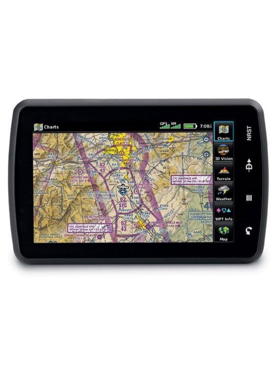
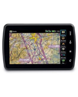
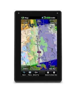
Complete Flight Mapping
The aera 660 comes preloaded with comprehensive flight mapping, terrain and obstacle alerts, SafeTaxi® charts for the U.S., Europe, and Canada, and the AOPA Airport Directory or optional AC-U-KWIK global airport directory. Access local fuel prices (U.S. only) and utilize the graphical Terrain page for both overhead and vertical profile views. Switch to IFR map mode to navigate on high or low enroute airways, with the ability to reference MEAs (Minimum Enroute Altitudes) and distances between intersections. Vertical navigation (VNAV) guidance simplifies en-route transitions.

Connectivity with Your Panel
With an optional power/data cable (sold separately), the aera 660 seamlessly connects with Garmin avionics. It accepts flight plans from your GTN 750/650 navigators and can upload frequencies to the standby position of your GTR 200 Comm radio, GTR 225 Comm radio, or GNC 255 NAV/COMM radio. Additionally, it provides GPS position data to Garmin NAV/COMM radios, facilitating frequency lookup.
Wireless Weather and Traffic
Bluetooth® connectivity via Garmin Connext technology allows the aera 660 to interface with compatible devices, reducing cockpit clutter. Pair it with a Garmin GDL® 52 portable ADS-B/SiriusXM® receiver or GTX 345 all-in-one ADS-B transponder to access subscription-free weather¹ and advanced traffic alerts. This includes TargetTrendTM relative motion tracking and TerminalTrafficTM for enhanced situational awareness. The device also enables wireless control of Garmin VIRB® action cameras.

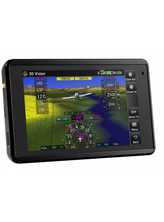
Revolutionary 3D Vision
Experience a new dimension of situational awareness with the revolutionary 3D Vision technology. This feature offers a virtual 3-D perspective view of the terrain derived from GPS/GLONASS and the onboard terrain database. Swipe your finger across the touchscreen to rotate the view and visualize land and water features, obstacles, runways, and airport signposts in relation to your aircraft. When connected to an attitude source through a Flight Stream 210 or Flight Stream 510, a GDL 52 series portable data link, or a GTX 345 ADS-B transponder, Garmin SVX synthetic vision and attitude command bars are seamlessly integrated into your display.

Enhanced Terrain Awareness
The aera 660’s forward-looking terrain avoidance capability predicts the presence of towers or obstacles in advance. It highlights these areas with amber or red overlays, ensuring you remain aware of potential hazards. Garmin WireAware™ wire-strike avoidance technology graphically overlays Hazardous Obstacle Transmission (HOT) lines on the moving map page, even indicating MSL and AGL heights. An optional full database that includes all powerlines is also available.
Stay Current with Ease
With the aera 660, you can update databases via Wi-Fi, eliminating the need for a computer connection. A single annual subscription covers all your database needs, including the Garmin Navigation Database (U.S., Canada, Mexico-version only).
All-in-One Functionality
The aera 660 serves as a Class I or Class II electronic flight bag, reducing reliance on paper charts. It comes preloaded with U.S. geo-referenced VFR sectional and IFR enroute charts, with optional European and Canadian VFR and IFR charts and airport diagrams available. In IFR map mode, it displays victor airways, jet routes, leg distance, and more, catering to pilots who prefer Jeppesen charts via built-in ChartView capability.
Home Dock Convenience
For desktop use at home, office, or FBO pilot lounges, the aera 660 home dock securely holds your device. It keeps your unit charged and positions the touchscreen for convenient use in setting up flight plans, reviewing airport information, and performing essential preflight planning tasks.
A Dedicated Partner
With its extensive feature set, the aera 660 bridges the gap between portable and panel-mounted avionics. It’s a dedicated partner, ready for action right out of the box, and it’s here to elevate your flying experience.
Only logged in customers who have purchased this product may leave a review.
Reviews
There are no reviews yet.